The Geography
Anghir is an area clenched between a seashore and impassable hillsides of the Grey Mountains...
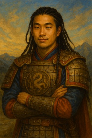
Anghir is an area clenched between a seashore and impassable hillsides of the Grey Mountains, that turn to the East, into the mainland. The Chyrrkhans call these mountains Erighi i Roghíril, the Lion Mountains, for the numerous population of the mountain lion.
The northern border of these mountains is created by the sacred mountain Maghrin. Two rivers spring at its base – Chermaghin, the Snowy River, and Urughin, the Eastern River, which disappears in the plains of Urughir, and legends say that it ends in the faraway eastern sea.
South from Maghrin, on the hillsides of Erighi i Roghíril, springs the longest river of Anghir, Birighin, the Red River, having its name given by the color of its waters. However, it gets its red shade only when it begins to erode the red soil of the plains of Anghir.
Upstream, Birighin passes a lonely mountain called Nobi Eragh, the Tin Mountain, at which stand the renowned workshops of the southern Erighani – the Zerilans.
Midstream, Chermaghin and Birighin come so near to each other that their riverbeds are less than a mile apart and only divided by a high rocky ridge upon which the city of Chyrrkhan kings stand, Dowril Awrakh. To the east from the city, clenched by those two rivers, rises a high plateau, the home of a small tribe of the Korlans.
After Birighin leaves the rolling foothills, it turns into slow, meandering river that, further down the stream, creates several islands which are the core of the area of the western Harghani. Its journey ends by the seashore with a short, but wide waterfall which continues over the coastal cliffs.
It’s necessary to mention that the entire shore of Anghir, except for the mouth of Chermaghin, is created by impassable rocky cliffs.
In the south, the border between Anghir and the wild Bôghir is created by the black stream of Madrughin, the Border River, which zigzags along the deserted and vast volcanic fields. Drughnor, the Hellish Mouth, is a volcano standing south from Madrughin and according to Chyrrkhan legends, it is the entering gate to the underworld. In the foothills of Erighi i Roghíril lies a large lake, Meri Ochir, the Blue Lake, from which flows Bôghin, the Wild River, which is the mightiest tributary of Birighin.
There is one more place that is necessary to mention for our story, the so-called Great Breakage, Darli Grot.
The plateau on the hillsides of the Lion Mountains first descends slowly into the eastern plains only to end with a steep slope where the only passable way is a narrow gorge eroded by the waters of Bôggur, the Wild Stream. At the mouth of this gorge stands the mysterious Great Eastern Fortress of the Sharians‘, Dar Uru Awrakh.